Cutting it Close: Florida’s Fate May be a Matter of Miles
Tony WintonSeptember 2, 2019
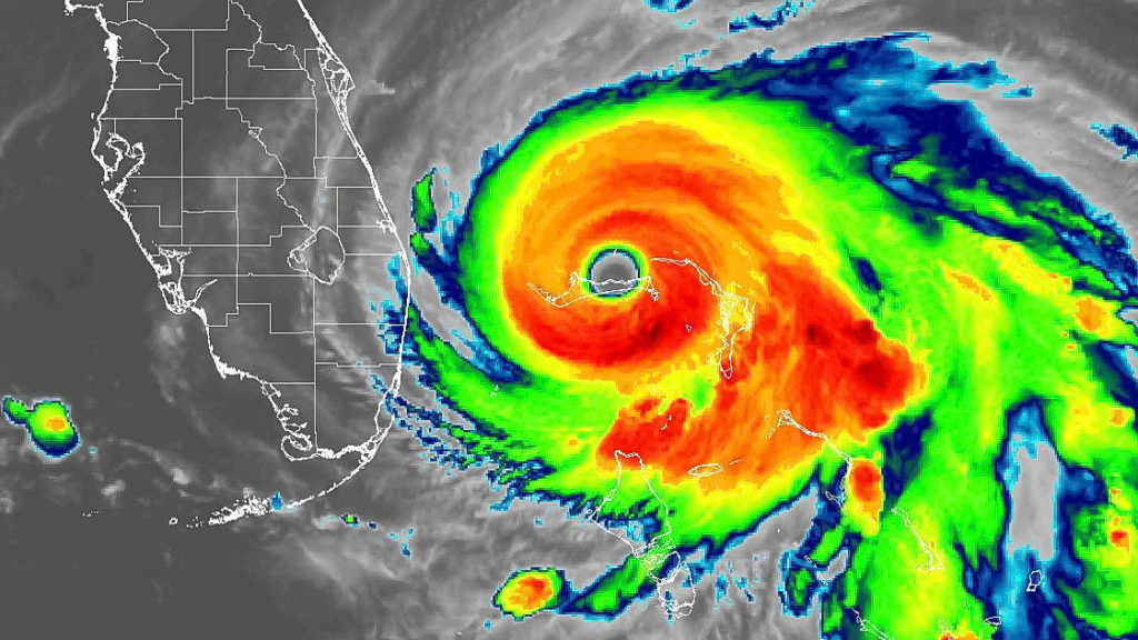
In this infrared image taken by the GOES Satellite at 6:30 a.m. Sept. 2,2019, Hurricane Dorian is stalled over the Bahamas, about 115 miles east of West Palm Beach. Dorian is a Category 5 storm with winds of 165 mph (NOAA via Key News)
Deadly Hurricane Dorian essentially stalled its progress early Monday, 30 miles east of Freeport on Grand Bahama Island, and 110 miles east of West Palm Beach. It was still an extremely dangerous Category 5 storm with winds of 155 miles per hour at 11 a.m. EDT, barely moving west at 1 mph.
As Key Biscayne and the rest of South Florida waited, Miami schools, seaports, and courts announced closures, and drawbridges were locked down. See list of closures
About 1,000 flights have been canceled. Fort Lauderdale’s airport will close Monday at noon, but Miami International remains open. Virgin Trains, formerly Brightline, suspended service.
Hundreds of miles of the Florida coast were under alert, running from Golden Beach all the way to the Georgia state line, with Hurricane Warnings covering the stretch from Jupiter Inlet to the Volusia/Brevard County line.
Miami had a 50% chance of getting hit with at least tropical-storm force winds. Key Biscayne, Miami-Dade County, and the state all remained under a state of emergency. Mayor Mike Davey urged residents to “remain alert.” Conditions were expected to slowly worsen Monday afternoon through Tuesday evening, forecasters said.
We may be seeing some strong winds later today. Please take care to keep yourselves and your neighbors safe. Secure any outdoor furniture, construction materials and anything else that might be a hazard in a wind event. If you are outside, please take care and monitor forecasts.
— KBMayorMike (@kb_mayor) September 2, 2019
According to a Monday morning advisory, Florida’s east-central coast may see a “brief tornado” sometime between Monday afternoon and Monday night.
South Carolina Gov. Henry McMaster issued an order Sunday for the mandatory evacuation of his state’s entire coast. The order, which covers about 830,000 people, was to take effect at noon Monday, at which point state troopers were to make all lanes on major coastal highways one-way heading inland.
“We can’t make everybody happy, but we believe we can keep everyone alive,” McMaster said.
A few hours later, Georgia’s governor, Brian Kemp, ordered mandatory evacuations for that state’s Atlantic coast, also starting at midday Monday.
Authorities in Florida ordered mandatory evacuations in some vulnerable coastal areas. North Carolina Gov. Roy Cooper warned his state that it could see heavy rain, winds and floods later in the week.
Forecasting Challenge
Dorian has proven a very difficult storm to forecast. Steering currents collapsed, meaning it will linger and cause a “prolonged period of catastrophic winds and storm surge,” said Hurricane Specialist Richard Pasch. Eventually, steering currents will re-emerge and draw Dorian northward, forecasters said. The problem is how to communicate uncertainty to the public.
When meteorologists have a general idea where the monstrous storm is going, but have to choose a point on the map instead of a general place, it can make it seem more specific than it really is.
And much of the Florida coast is inside that cone.

In this graphic from the National Hurricane Center, the track for Hurricane Dorian is seen as of 5 a.m. Sept. 2, 2019 (National Hurricane Center via Key News)
“This thing is perilously close to the state. I think we should all hope and pray for the best, but we have to prepare that this could have major impacts on the state of Florida,” said Florida Gov. Ron DeSantis. “If you look at the National Hurricane Center’s current track, I think it ends up within 30 miles of the coast of Florida. Well guess what? You do just a touch of a bump one way or another, and you have a dramatic difference all of a sudden.”
Center Director Ken Graham is telling residents don’t bet on safety just because his office specific forecast track has the storm just a bit offshore.
“The cone is so important,” Graham said.
And making matters more touch-and-go is that with every new forecast, “we keep nudging (Dorian’s track) a little bit to the left,” which is closer to the Florida coast, he said.
Dorian is a powerful but small hurricane with hurricane-force winds Sunday only extending 29 miles to the west, but they are expecting to grow a bit. That makes forecasting the storm’s path along the coast — either just off the coast, skirting it or moving inland with a direct hit — delicate and difficult. Just a few miles west or east makes the difference between devastation and bad but not horrible damage, meteorologists said.
“Where it doesn’t directly hit, it’s not going to be a huge problem,” Colorado State University hurricane researcher Phil Klotzbach said.
With a big, sloppy hurricane — say 50% larger in size — all of Florida would be under a serious threat, but that’s not the case, said University of Miami hurricane researcher Brian McNoldy.
This is what makes this a nightmare for forecasters, McNoldy said.
It’s a combination of the small size, close-in track, like Matthew in 2016, and weak steering currents. That means just a smidge of a movement days ahead of time, while Dorian is in the Bahamas, can reverberate and mean a direct hit or not, said private meteorologist Ryan Maue.
That can happen just because of the timing of when Dorian’s eyewall collapses and is replaced, which happens normally in storms.
Adding to that problem is Dorian’s slow, almost snail-like pace. What initially looked like a Labor Day storm for the U.S. is now approaching Tuesday and Wednesday.
“People are getting impatient with this,” McNoldy said. Because the threat seems to keep sticking around, it could be a problem getting the right message across, he said.
Klotzbach said he thinks the U.S. East Coast will get “scraped,” but Dorian will stay just offshore, something Maue agrees with.
Maue warns, however, that two days of high waves and heavy storm surge — the hurricane center is predicting 4 to 7 feet from West Palm Beach north to Cocoa Beach area — could severely damage Florida’s beaches.
Residents along Florida’s coast are relieved that the forecast, for now, doesn’t have Dorian making landfall in Florida, but are still preparing for the worst.
Kevin Browning in Vero Beach has put up hurricane shutters, bought a generator and is stocked with supplies.
“I’m thanking God, now, that it’s turned a little bit towards the east, but that’s a forecast, and we never know. I’m just praying and trying to make sure that everybody’s safe. I feel for the Bahamas and I’m praying for them, and I thank God it’s not coming directly to us right now.”
___
Associated Press Science Writer Seth Borenstein contributed to this report